Jogyakarta 2012-7-1
 |
| A volcano seen on the airplane |
We had breakfast early in the morning in Pullman Hotel in
Jakarta and paid Mei the costs for the remaining trip up to Lombok. Yinfa and
his family didn’t join us for the remaining of the trip, and therefore, our
number was reduced to 11. I didn’t have
the window seat in the airplane, and could not take much photos from the air,
however, I managed to take the photo of the majestic volcano (Gunung Sumbing?). Its flank had been
heavily cultivated all the way up to 2/3 of its height. At its peak, I saw the
feature of a caldera and a depression followed by a new cone shape peak with a
crater in the middle. This volcano apparently was not the tallest in the
mountain complex, another one was showing its higher peak in the backgraound.
The airplane made a turn around the volcano, and I took a photo of its active
crater. I must be facing south when this photo was taken because the Indian
Ocean was in the background. The colour of the crater was light to deep muddy
orange like that of a iron furnace. It was a strong contrast to the bluish
colour of the remaining of the mountain.
 |
| Seats of the motorbikes were covered by cardboard |
 |
| Street performers |
We arrived at Jogyakarta at 10 am. The airport was small, clean and orderly. Our bus was a new bus similar to that we took to Bukit
Tinggi. We quickly boarded our bus to visit the Keraton (the palace). The
streets were straight and clean, and the sidewalks were well maintained. Many
of the streets were one way, and when the traffic light changed, all kinds of vehicles
pouring into the intersection like flood water. The parking attendants on the street would
cover the seats of the parked motorbikes with cardboard boxes to keep it cool from
the hot sun. We saw two men each held a whip in his hand standing in front of
the red traffic light in an intersection. One of them wore a red pants like in
a circus. They were probably street performers begging for money but they
certainly looked more like a road robbery. The horse cart had four wheels, two
small wheels in the front and two bigger wheels in the rear, and looked like
that used in Europe. It must be more comfortable to ride than the local two
wheels carts.
 |
| Dancers entering the hall |

The Keraton was the palace for the Sultan of Jogya. It was
now opened to the public except the building which was used as their residence.
There were many souvenir stalls crowding the road toward the entrance of the
Keraton. I was surprised that some cars were still tried to squeeze in to get
parking closer to the gate. The palace consisted of several courtyards partitioned by
walls and pavilions and buildings. In the largest courtyard, there were low and
big halls, and many tall trees. The sawo (naseberry) trees in the palace was famous of
its small fruits. None of the buildings in the palace had the appearance of
greatness and luxury. The courtyard was big and the ground was covered by
cement and bricks tiles or sands. There was not a single grass or weed found on
the ground. Big crowd were gathering around a big hall. Along the peripheral of
one side of the hall was occupied by musicians playing traditional Javanese musical instruments. Four young female dancers in gorgeous batik costumes wearing a
gold colour crown with a pink feather slowly and graciously entered the hall in
barefoot. They started dancing when they got to the middle of the hall. At the
end, they walked slowly to the other end of the hall, then stopped, turned
around and walked back to the side where they entered the hall. The next
performer was a male wearing a famous and familiar mask of the clown Petruk. We finished our visit
by seeing some museums in the palace.
 |
| Beautifully carved wooden panel |
 |
| Performers in Hotel Santika |
We passed a wide boulevard with wide sidewalk. The spaces of the later were taken over by a
long row of food stalls. Like in Jakarta, the bus stop was also elevated but
smaller. Probably there was no long tandem bus running in the city. I saw a
Chinese temple Fuk Ling Miao
福霊庙 on Jalan Senopati. It had the traditional Chinese
roof. We had lunch in a big chicken restaurant
but the food was only ordinary. After lunch we visited a silver and batik shop on Jalan Nyi Pembayun where we
saw some workers making silver jewelleries, and there was a demo of how batik was made using wax. Our last stop was another
batik shop on Jalan Nogosari Lor, and I was surprised to find many beautifully and richly carved
wooden panels doors and ceiling inside the store. It was almost dark when we
arrived
in
Hotel Santika where we stayed. Two male musicians and a female singer were performing traditional songs at the stage on one end of the
reception hall.
Jogyakarta 2012-7-2
 |
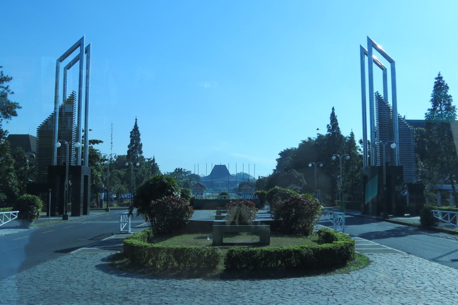
| Gajah Mada University |
The breakfast in Hotel Santika had many selections of local
dishes and deserts. I tried many of them and they were all good. Our first stop
was to see the volcano Gunung Merapi. On the way, we passed the entrance to the
campus of Gajah Mada University, the famous university in Indonesia. From that entrance, one could clearly see Mt. Merapi far in the background. For
the first time, I saw a street person laying on ground in front of an abandoned
building in rags. He was probably insane.
 |
| Mt Merapi seen on Jalan Bebeng |
 |
| Mt Merapi seen in the car terminal |
 |
| Smoke puffing out of the crater |
We were travelling north along the busy commercial road Jalan Kaliurang, and we could only see stores after stores along the road. Only after we passed Jalan Bias in Ngaglik we started to see the farmlands and the volcano in a distant. There was a fork south of Universitas Islam Indonesia, and instead of continuing north in Jalan Kaliurang, we turned right on a smaller road, and eventually turned right into Jalan Kalasan-Pakem. Soon the road turned north and became Jalan Bebeng. The land along the road was heavily
cultivated and we went through villages after villages, and we could see the volcano in front of us along Jalan Bebeng. The road took us straight into a car terminal with an altitude of 1,080 m. This was the last terminal for all cars visiting Mt Merapi. There were some shops in simple huts selling simple foods, deinks and souvenirs, and other services catering for the needs of the tourists. When we arrived, we were lucky to see the peak of the volcano was not
hidden behind clouds. And soon we saw smokes started to puff out of its
crater. It lasted for about half an hour. The land was heavily cultivated around the terminal, and the whole mountain slope was covered in green
vegetation. there was a touring service for hire and they used old Indian jeeps. We hired
three jeeps to tour the devastated area damaged during the last explosion.
 |
| The route of the lava flow |
 |
| Large boulder from the last eruption |
 |
| An old woman walking alone in Mt Merapi |
The jeeps took us down on a trail, and soon we were on a bumpy dirt road. The ground was covered by
gray volcanic sand, and we saw new plants were starting to growth on the sand.
We passed many ruins of houses flatten or burned down by the hot pyroclastic
flow from the eruption. In front of an old dam, we saw the huge amount of sands
and rocks brought down. And people had started digging and transported it in
trucks. An old village woman was carrying a big bag on her back, we stopped and
Mei gave her some donations. She was very happy for this unexpected kindness.
We went slightly up the slope of the volcano almost to the end of the trails, and reached an open plain resulted from the destruction of the last eruption. And
large boulders the size of a jeep and
rocks littered the area. A hut had been set up next to a trail, and a person
was holding a box for donation. There were a few huts in this area serving
drinks and simple foods for the visitors. We bought some salak which we had not
seen in the market. Instead of the dark brown colour on it scaly skin, the
colour was much lighter and close to gold. Its taste, however, was the same as
the regular fruits. Seedlings of a variety of trees were already planted and
started to growth. I didn’t know if they would achieve their maturity before
the next eruption would destroy them. I left my GPS on our van, and therefore, no GPS track for the trip on the jeep. Fortunately, I carried a camera with GPS capability, and therefore, we had recorded the locations of the photos.
 |
| Salak grove |
 |
| A Chinese cemetery at Sucen |
We left the car terminal and drove to Candi Borobudur, a Buddhist temple. We went south along the same road Jalan Bebeng that we had taken before. We then turn west to join Jalan Kaliurang going south. On this stretch of the road we saw some beautiful paddy fields and villages. We also started to see salak groves hidden behind other trees. We then turned west on Jalan Kalasan-Pakem. Along this road, we saw clearly many salak groves growth next to the wet paddy
fields, and some grew along the road. Salak or snake fruit tree
(Salacca zalacca) was a kind of palm tree only about three metres high, and
the fruits were grown in a cluster at the base of the palm. We then joined Jalan Magelang going north. We started to see shops along the road selling Buddha and other religious rock statues. And at Sucen we saw a
neatly maintained Chinese cemetery on a low hill.

We turned south-west into Jalan Raya Borobudur south of Bojong. There was a welcoming arch at the entrance to this road. We arrived at Borobudur at 10:43 am. The site had now been
designated as UNESCO World Heritate site in 1991. The ground was cleaned, beautified and fenced. However, the tall trees along the walkway in
the courtyard had made it difficult if not impossible to take a full photo of
the temple. During my first visit in 1988, the temple was more clearly visible
in a far distant. I didn't find and feel any difference between the two visits.
 |
| The corridor on one of the square platform |
 |
| Niches on the square platforms |
 |
| Stupa on the circular platforms |
In a far distant, the temple looked like an inverted bowl, but at closer look, it had the shape of a square step pyramid built to
cover a hill. At the lowest level was the 123x123 metres footing, and then
there were 5 levels of square platforms, and 3 levels of circular platforms and
finally was a large stupa at the top reaching a height of 35 metres above
ground. There were stairways at the centre of each side of the pyramid. The
square platform had two walls separated by corridor, and the walls were
decorated with bas-reliefs depicting the life of Buddha; the life of ordinary people in palace,
village and market. The wall became an arched gate when it crossed the stair.
The top part of the walls was decorated with numerous niches and inside
each niche there was a life size Buddha statue. The façade of the niche was
beautifully carved and its opening was arched and adorned with Kala head. There
were also a few small stupa decorating the top of the niche. From a distant, the temple
was simply rows of niches on many levels of terraces. Among the
many bas-reliefs on the walls, there were some depicting double outrigger large
boats which were probably used for ocean going voyages at that time. A replica
of the boat had been built and tested in August 2003 to February 2004, and it reached West Africa after passing the Cape of Good Hope.
 |
| Buddha statue inside the stupa |
 |
| An outriggers boat shown on the bas-reliefs |
I walked around the foot of the temple trying without
success to take a full photo of the temple. I then climbed up the temple to the
first or the second square platform, and started walking along the corridor
taking photos of the beautiful bas-reliefs on the walls. It took me over 20
minutes to complete the circle. I was concerned that others might be looking
for me, and decided to quickly ascended to the top and at the same time tried
to look down at the base of the temple if I could find Ching. I saw Yet at the
base who was apparently looking for me. I joined them and we walked back to the
entrance. I didn’t have chance to study the bas-reliefs. My impressions were
the figures were rough due to the large grains in the texture of the andesite
rock used in the construction. All facial and physical features of Buddha, gods
and human being resembled that of the local native. The shape of the people in
the bas-reliefs tended to be chubby which might indicate the fashion of that
time. I didn’t see any beautiful apsaras like in Angkor Wat. Experts estimated
that the temple was built in 800 CE which was many hundred years earlier than
the construction of Ankor Wat in Cambodia. I had my GPS with me, but somehow, I had problems to attach the locations of many photos with data on the GPS track.
 |
| Buddha statue in a niche |
We left the temple at 12:40 pm returning to Jogyakarta. We
were thirsty and stopped at a roadside restaurant to buy some green coconuts.
They tasted very good and refreshing. After returning to town, we went to do some shopping for souvenirs
in the shops in Tugu Station, where the prices were generally cheaper. There
were many big tourist buses in the parking lot. It was already dark when we
left the station, and someone suggested that we went to Alun Alun, a big square
not far from the station. The biggest attraction there was to ride or watch the
parade of many human powered vehicles decorated with all kinds of neon lights.
We were hungry, but couldn’t find any descend restaurant. We finally settled in
a small café. It was very clean and ran by an unprofessional couple. Even some
simple foods like fried potatoes took a long time to get to the table. But it
tasted very good.
Jogyakarta 2012-7-3
 |
| Candi Prambanan |
We left the hotel at 6 am to beat the crowded tourist at
Candi Perambanan, a Hindu Temple. We traveled east on Jalan Laksamana Adi Sucipto, and passed the airport bearing the same name. The road then became Jalan Raya Jogya Solo. At Prambanan, we turned north to the temple bearing the town's name, and arrived there at 6:45. There were already
many visitors. The candi was built about 100 years after the Candi Borobudur. It probably reflected the regain in popularity of Hindu religion in the area. Unfortunately, it suffered the
same fate of abandonment as the Borobudur after the population turned into
Muslim. It was also re-discovered in the 10th century by the Britain
during its ruling of the Duth East Indies. The site had been designated as UNESCO World Heritage Site.
 |
| Shiva temple |
The main focus in the fenced area was an elevated square platform surrounded by
stone walls. The ground outside of these walls was littered with stone blocks
which were the remains of hundreds of small ruined temples. On the platform,
there were two rows of large temples. The most prominent row of temples was
called Trimurti temples, and it consisted of the temples for the
three Gods (from south): Brahma, Shiva and Vishnu. Directly in front of these temples were
the Vahana temples of each respective Gods, the swam Hamsa for Brahma, the bull
Nandi for Shiva and the eagle Garuda for Vishnu. Between the Trimurty temples
and the Vahana temples were two small temples near the edge of the platform and were called the
Apit temples. And at the four cardinal directions near the gate were four
small temples called Apik temples. Four more small temples were found at the
four corners of the platform and they were called Kelir temples. All of them were
built of stone blocks and had been restored after being damaged by earthquake
and other factors.

 |
| Candi Prambanan |
The Trimurti and the Vahana temples all had the traditional
shape of a Hindu temple, slim and pointy like a tower. The whole complex were located at the
foot of Mount Merapi, a very active large volcano, and their towering shape
made them vulnerable to earthquake generated during the frequent eruptions of
the volcano. Each of the temple was erected on its elevated terrace surround by
stone walls. And the walls were topped by stupa like balusters. The towering temple was
built up in the centre of the terrace. The top was like a pyramid, and along its pointy
slope toward the top, the space were divided into five levels. Many stupa were erected around each level. The size of
the stupa was gradually decreased toward the top, however, the largest and the
tallest single stupa was in the top level. The stupa was bulging and had
creases from top to bottom like pumpkins. The exterior surfaces of the temples
were decorated with beautifully carved bas-reliefs. I felt the detail features of the
bas-reliefs were superior than those in Candi Borobudur.
 |
| Candi Sewu |

I promised to stay with the group to make it easier to
control the visiting time. In my first visit in 1988, the Shiva temple was opened and we could enter its chambers to see statues of Hindu gods inside. It was now fenced and we could not get in. We spent a total of
only 30 minutes to walk through the temple ground. I regretted of not being able
to see them in more detail. A large group of boy and girl scouts were unloading
their gears and supplies from trucks in a large open field near the exit. We
took a transport ride to go back to the park entrance. On the way, we had a
stop in front of a Buddhist temple, Candi Sewu. The whole complex was fenced,
and the ground was mostly covered by piles of stone blocks which were the
remains of hundreds of temples. The major and some minor temples had been
restored. They had the shape of the temples found in Prambanan, but the stupa
was bulkier and had no creases.
 |
| Truck wearing a turban |
The ride dropped us in front of rows of souvenir shops, and
we spent just as much time here as we spent on the temple ground. Somehow, my GPS stopped working, and I didn't have any GPS tracks for the remaining of the trip. We left at
8:40 am and passed Klaten on our way to Surakarta (Solo). Ching parents lived here before
they moved to Cibeber. On the road, we saw several trucks with its tall load
covered in white canvas. It looked like they were wearing tubans.
 |
| A huge hall in Keraton Surakarta |
 |
|
Inside the keraton |
The street in
Surakarta was also clean and orderly like in Jogyakarta, and we arrived at the
Keraton Surakarta at 10:30 am. There were much less visitors here than in
Keraton Jogyakarta. We passed a large rectangular grass field. On one side there
was an old white building dated 1874, and was the mess for cavalry and
artillery staff. Inside the palace was a huge low hall similar to that seen
in the keraton in Jogyakarta but was larger. It was connected to another
smaller hall in front of the residential complex. The complex was a square with a large beautiful
garden in the middle. The front row was a large open hall which was used
to display royal photos and valuable goods in the palace. And the building
surrounding the other three sides of the garden had very wide corridors. The corridor was well
furnished and decorated, and was used for dining and other common activities of
the royal family. The building had been partitioned into rooms for living
spaces. We spent an hour to get some feelings of the life in the keraton.
 |
| Trip around Jogyakarta |
We left at 1:45pm, had another chicken lunch and went
shopping at an expensive batik shop. We didn’t buy anything there, and then
went for more shopping in a mall next to the bus terminal. We returned to
Jogyakarta in late afternoon, had a short rest, changed into a nicer clothes to
attend a Ramayana dance performance in
an open stage in Prambanan. There were
already a big crowd when we arrived. Fortunately, all seats were numbered, and
we were assisted by an usher to get to our seats. I enjoyed the performance and
lighting on the towering temples in the background. We returned to our hotel
late at night.
More photos can be seen by
searching "lku99999, photo" in Google.


 I promised to stay with the group to make it easier to
control the visiting time. In my first visit in 1988, the Shiva temple was opened and we could enter its chambers to see statues of Hindu gods inside. It was now fenced and we could not get in. We spent a total of
only 30 minutes to walk through the temple ground. I regretted of not being able
to see them in more detail. A large group of boy and girl scouts were unloading
their gears and supplies from trucks in a large open field near the exit. We
took a transport ride to go back to the park entrance. On the way, we had a
stop in front of a Buddhist temple, Candi Sewu. The whole complex was fenced,
and the ground was mostly covered by piles of stone blocks which were the
remains of hundreds of temples. The major and some minor temples had been
restored. They had the shape of the temples found in Prambanan, but the stupa
was bulkier and had no creases.
I promised to stay with the group to make it easier to
control the visiting time. In my first visit in 1988, the Shiva temple was opened and we could enter its chambers to see statues of Hindu gods inside. It was now fenced and we could not get in. We spent a total of
only 30 minutes to walk through the temple ground. I regretted of not being able
to see them in more detail. A large group of boy and girl scouts were unloading
their gears and supplies from trucks in a large open field near the exit. We
took a transport ride to go back to the park entrance. On the way, we had a
stop in front of a Buddhist temple, Candi Sewu. The whole complex was fenced,
and the ground was mostly covered by piles of stone blocks which were the
remains of hundreds of temples. The major and some minor temples had been
restored. They had the shape of the temples found in Prambanan, but the stupa
was bulkier and had no creases.


No comments:
Post a Comment